
In a project that aims to pull a new generation of students toward science and technology, Microsoft and NASA have teamed up to create what they say is the largest seamless, spherical map ever made of the night sky, as well as a true-color, high-resolution map of Mars that users can explore on their computers in 3D.
The mission, Microsoft and NASA say, is to inspire today’s students and spark interest in the STEM fields, and it appears to be working: In studying photos of Mars taken by a NASA spacecraft, a group of seventh graders in California earlier this year discovered a previously unknown cave, as well as lava tubes that NASA scientists hadn’t noticed.
“What we’re trying to do at NASA is make our data more accessible,” said Chris Kemp, chief technology officer for NASA, in an interview with eSchool News, “and we’re doing that by connecting students in the classroom and at home to a user-friendly platform.”
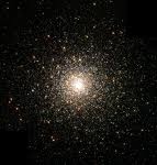
Called Terapixel, the night sky project is now available for viewing with Microsoft’s WorldWide Telescope, a free, web-based program that functions as a virtual telescope, bringing together imagery from ground and space-based telescopes to enable seamless, guided explorations of the universe. Created with Microsoft’s Visual Experience Engine, it enables seamless panning and zooming across the night sky, blending terabytes of images, data, and stories from multiple sources over the internet into an immersive experience.
The WorldWide Telescope program debuted in May 2008 and includes images from the Hubble Space Telescope, Sloan Digital Sky Survey, and many more sources. Users can browse through the galaxy at their leisure or take guided tours developed by astronomers, academics, and sometimes very smart middle schoolers.
“The U.S. really needs to get re-stimulated by science,” said Tony Hey, corporate vice president of Microsoft External Research, “and we’re trying to do that by providing full access, in a visually stunning and understandable way, to astronomers’ data and research.”
The night sky project, as well as the Mars 3D project, began 50 years ago as photos were taken of the night sky by ground-based survey telescopes. Over five decades, thousands of images were taken by NASA and stored with the Digitized Sky Survey. The challenge then became: How can scientists take these various images and make them into a single, unified image for exploring via computer?
According to Hey, that’s where Microsoft’s Project Trident came in.
Built on the Windows Workflow Foundation, Trident is a “scientific workflow workbench,” an open-source program that allows scientists to visualize and explore data; compose, run, and catalog experiments as workflows; and estimate the cost of the resources that such a workflow will require. Microsoft’s research department developed Trident as a tool for oceanographers to analyze and synthesize data coming from sensors on the ocean floor, but it became a logical choice to analyze and piece together data about the night sky, Hey said.
Using Trident and the DryadLINQ interface for Microsoft’s .NET platform, a programming environment for writing parallel data applications running on large computer clusters, scientists were able to combine thousands of images and systematically remove differences in exposure, brightness, noise floor, and color saturation—creating a “terapixel” image: a complete, spherical, seamless, panoramic rendering of the night skies that, if displayed at full size, would require 50,000 high-definition televisions to view.
Using these software tools reduced the time it took to run one iteration of the image from weeks to hours, making the creation of an image of this size and quality possible for the first time.
The entire process took only six months, said Hey, which is a breakthrough in this type of project. “Since it’s the first time we’ve done it, of course you learn a lot of things, and we’re looking forward to expanding this process,” he said.
The WorldWide Telescope’s Night Sky view is also available using Bing’s street view feature, allowing users to look up at the night sky from a particular area on the map. Inside Bing Maps, users first need to click on “Map Apps” and select WorldWide Telescope to enable the program.
The app is not just for identifying constellations and planets, as the menu allows users to load all data from sky surveys, the Hubble Telescope, and other astronomy data sources.
The 3D Mars project began in the same vein, with NASA having the data, but needing the technology for presentation.

“3D and the seamlessness are definitely de facto standards of the future,” said Kemp. “Thanks to Microsoft as part of our 2009 Space Act Agreement, the fully interactive images will allow viewers to virtually explore the red planet and make their own scientific discoveries.”
Kemp said new features include a true-color map of Mars, a 3D rendering of the surface of the planet, and exclusive interactive video tours with two noted NASA scientists, Drs. James Garvin and Carol Stoker.
According to Hey, WorldWide Telescope has had 1.4 million downloads in the last year, with the site receiving between 8,000 and 16,000 unique visitors per day.
The site can also be translated into simplified Chinese, German, and Spanish.
Hey explained that, although astronomy and science are currently the Telescope’s main focus, Microsoft soon hopes to use the same technology for the humanities.
“We’d like to soon be able to offer 3D, seamless representations of geography, earth sciences, and much more,” he said, with the help of Microsoft’s many partners in research fields and with universities.
Kemp concluded: “For NASA, it’s really about the collaboration. You wouldn’t believe how many times students and universities have identified or discovered what we haven’t. Just by giving people access to information, we can begin a truly mutually beneficial relationship.”

- #4: 25 education trends for 2018 - December 26, 2018
- Video of the Week: Dealing with digital distraction in the classroom - February 23, 2018
- Secrets from the library lines: 5 ways schools can boost digital engagement - January 2, 2018